


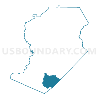
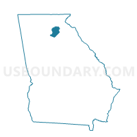
139010 - MORGAN I Voting District, Hall County, Georgia
About
Outline

Summary
| Unique Area Identifier | 562126 |
| Name | 139010 - MORGAN I Voting District |
| County | Hall County |
| State | Georgia |
| Area (square miles) | 16.87 |
| Land Area (square miles) | 16.69 |
| Water Area (square miles) | 0.18 |
| % of Land Area | 98.92 |
| % of Water Area | 1.08 |
| Latitude of the Internal Point | 34.15153210 |
| Longtitude of the Internal Point | -83.82994960 |
Maps

Graphs
Select a template below for downloading or customizing gragh for 139010 - MORGAN I Voting District, Hall County, Georgia


Neighbors
Neighoring Voting District (by Name) Neighboring Voting District on the Map
- 01302 - 02 Voting District, Barrow County, GA
- 135159 - DUNCANS D Voting District, Gwinnett County, GA
- 139011 - MORGAN II Voting District, Hall County, GA
- 139012 - MORGAN III Voting District, Hall County, GA
- 139013 - CANDLER Voting District, Hall County, GA
- 139036 - FRIENDSHIP I Voting District, Hall County, GA
- 139038 - FRIENDSHIP III Voting District, Hall County, GA
- 1571765 - PORTER Voting District, Jackson County, GA
Top 10 Neighboring County Subdivision (by Population) Neighboring County Subdivision on the Map
- Dacula-Rocky Creek CCD, Gwinnett County, GA (91,691)
- Gainesville CCD, Hall County, GA (88,853)
- Flowery Branch CCD, Hall County, GA (36,352)
- Auburn CCD, Barrow County, GA (18,594)
- West Jackson CCD, Jackson County, GA (17,165)
- Oakwood CCD, Hall County, GA (14,068)
Top 10 Neighboring Place (by Population) Neighboring Place on the Map
Top 10 Neighboring Unified School District (by Population) Neighboring Unified School District on the Map
- Gwinnett County School District, GA (793,941)
- Hall County School District, GA (145,108)
- Barrow County School District, GA (69,367)
- Jackson County School District, GA (44,509)
Top 10 Neighboring State Legislative District Lower Chamber (by Population) Neighboring State Legislative District Lower Chamber on the Map
- State House District 105, GA (91,944)
- State House District 31, GA (69,009)
- State House District 25, GA (64,506)
Top 10 Neighboring State Legislative District Upper Chamber (by Population) Neighboring State Legislative District Upper Chamber on the Map
- State Senate District 45, GA (256,939)
- State Senate District 47, GA (193,917)
- State Senate District 49, GA (190,699)
Top 10 Neighboring 111th Congressional District (by Population) Neighboring 111th Congressional District on the Map
- Congressional District 7, GA (903,191)
- Congressional District 9, GA (823,583)
- Congressional District 10, GA (738,248)
Top 10 Neighboring Census Tract (by Population) Neighboring Census Tract on the Map
- Census Tract 506.09, Gwinnett County, GA (11,696)
- Census Tract 12.01, Hall County, GA (7,839)
- Census Tract 13.01, Hall County, GA (5,452)
- Census Tract 101.03, Jackson County, GA (5,381)
- Census Tract 14.04, Hall County, GA (5,201)
- Census Tract 13.02, Hall County, GA (4,968)
- Census Tract 16.03, Hall County, GA (4,903)
- Census Tract 16.08, Hall County, GA (4,734)
- Census Tract 1801.03, Barrow County, GA (4,668)